Across the surface of Earth, the boundaries between land and water appear stable, almost permanent. Coastlines seem fixed. Harbors feel secure. Cities rise beside the sea with confidence that stone and engineering can resist waves forever. Yet the ocean does not recognize permanence. It shifts, rises, trembles, and advances with quiet patience—or sudden violence. Over centuries, it has swallowed entire urban worlds.
Human history remembers a legendary lost island called Atlantis, a powerful civilization said to have vanished beneath the sea. While that specific story remains a philosophical myth rather than a verified place, the idea behind it is profoundly real. Civilizations have indeed been claimed by water. Some sank in moments of geological catastrophe. Others drowned slowly as sea levels rose after the last Ice Age. Some slipped beneath the surface through gradual subsidence, their foundations weakening until waves moved in permanently.
These submerged cities are not fantasies. They exist as archaeological landscapes preserved underwater—streets filled with sediment, buildings encrusted with marine life, artifacts resting where human hands last touched them. Unlike ruins on land, underwater cities are sealed in environments that can preserve organic material, structural layout, and spatial relationships with extraordinary fidelity.
Marine archaeology has transformed our understanding of these drowned worlds. Using sonar mapping, underwater excavation, sediment analysis, and remote imaging, scientists reconstruct urban life that once flourished where fish now swim.
These cities are the real Atlantises—places where human ambition met planetary forces beyond control. Their stories are scientific records of geological change, climatic transformation, and the fragile balance between civilization and environment.
1. Thonis-Heracleion
For centuries, ancient texts described a grand Egyptian port city at the mouth of the Nile, a gateway between the Mediterranean world and the interior of Egypt. Greek historians referred to it as Heracleion, while Egyptian sources called it Thonis. Over time, its precise location vanished from knowledge. Scholars debated whether the city had ever truly existed.
Its rediscovery in 2000 transformed historical understanding of ancient maritime trade.
Marine archaeologists surveying Abu Qir Bay used geophysical scanning to detect anomalies beneath thick layers of sediment. What they found was astonishing: a vast submerged urban complex nearly 10 meters below sea level. Massive statues, temple foundations, harbor structures, and ship remains lay scattered across the seafloor.
Geological analysis revealed why the city disappeared. The region consists largely of water-saturated clay and sand deposited by the Nile. Over centuries, these sediments became unstable. Earthquakes and rising sea levels caused ground liquefaction—a process in which solid ground behaves temporarily like fluid under stress. Buildings lost structural support, collapsed, and sank gradually into the delta.
By the eighth century CE, the city had fully submerged.
Excavations have uncovered monumental sculptures of pharaohs, stone inscriptions detailing trade regulations, and dozens of shipwrecks preserved in oxygen-poor mud. These findings reveal that the city functioned as a major religious and commercial hub, controlling access between Mediterranean trade networks and inland Egypt.
Underwater preservation allowed archaeologists to study port infrastructure in remarkable detail. Anchoring systems, docks, and navigation channels remain visible in spatial relation to each other, offering rare insight into ancient maritime logistics.
This drowned metropolis demonstrates how river deltas—fertile and economically vital—can also be geologically unstable environments prone to catastrophic transformation.
2. Pavlopetri
Off the southern coast of Greece lies one of the oldest known submerged cities in the world, dating back more than 5,000 years. Unlike many underwater sites formed by sudden disaster, this settlement sank slowly, allowing researchers to observe a gradual environmental transition from land to sea.
The city was first identified in 1967, but its full significance became clear only after detailed mapping using sonar and digital imaging technologies. What emerged was an entire urban plan preserved beneath shallow coastal waters.
Streets form a recognizable grid. Buildings are arranged in organized blocks. Courtyards, chambers, and burial sites remain visible. Even evidence of drainage systems has been detected.
The remarkable clarity of this layout makes the site one of the earliest known examples of planned urban development.
Geological research indicates that tectonic activity gradually lowered the land while regional sea levels rose following the end of the last Ice Age. The combined effect slowly submerged the settlement. Unlike cities destroyed abruptly, this community likely adapted to encroaching water over generations before final abandonment.
Because submergence occurred progressively, structures remained largely intact rather than collapsing catastrophically. Marine growth now coats stone surfaces, but architectural form is still clearly recognizable.
Archaeologists use advanced 3D mapping to document the entire site without disturbing fragile remains. This approach allows detailed reconstruction of spatial organization, offering insight into Bronze Age domestic life, trade, and social structure.
This ancient drowned settlement reveals that urban planning—and vulnerability to environmental change—are deeply intertwined features of early civilization.
3. Port Royal
Few cities have vanished as suddenly and dramatically as this Caribbean port once infamous for wealth, trade, and piracy. In the seventeenth century, it stood as one of the busiest commercial centers in the Western Hemisphere.
On June 7, 1692, disaster struck with terrifying speed.
A powerful earthquake shook the harbor region, triggering widespread ground liquefaction. The city had been built on loose sand deposits saturated with seawater. When seismic waves passed through, the sand lost structural strength and behaved like liquid. Buildings tilted, collapsed, and slid downward. Entire streets plunged into the harbor within minutes.
A tsunami followed, sweeping debris across remaining structures.
Eyewitness accounts described ships carried inland by waves, houses sinking while occupants remained inside, and sections of city disappearing completely beneath the sea.
Modern underwater archaeology confirms these descriptions with striking accuracy. Excavations reveal buildings preserved almost exactly where they stood at the moment of collapse. Furniture remains in place. Everyday objects lie scattered across floors. Some areas show structural walls leaning at extreme angles, frozen mid-subsidence.
Sediment layers allow geologists to reconstruct the precise sequence of earthquake, liquefaction, and inundation. Organic materials such as wood and leather survive unusually well in low-oxygen underwater conditions.
This submerged city provides one of the clearest case studies of earthquake-induced urban destruction in recorded history. It demonstrates the devastating consequences of building large settlements on unstable coastal sediments in tectonically active regions.
4. Baiae
Along the coast of southern Italy once stood a luxurious Roman resort city famous for thermal baths, villas, and elite social life. It was not destroyed by sudden catastrophe but slowly consumed through geological transformation.
The region lies within a volcanic zone where the Earth’s crust gradually rises and falls due to subterranean magma movement—a process known as bradyseism. Over centuries, portions of the coastline subsided, allowing seawater to advance inland.
As ground levels dropped, streets and buildings slipped below the surface. Today, much of the ancient city lies submerged in shallow coastal waters.
Underwater exploration reveals elaborate villa complexes, mosaic floors, statues, and bath structures preserved beneath the sea. Marble surfaces once polished by Roman artisans now host marine organisms, creating a striking fusion of cultural and biological forms.
Archaeological study shows that submergence occurred gradually over centuries rather than through a single destructive event. Residents likely witnessed the sea creeping closer year by year until parts of the city became uninhabitable.
Marine growth patterns on architectural surfaces help scientists estimate rates of submergence. Sediment deposition reveals how coastal dynamics reshaped the region over time.
This drowned resort illustrates the long-term geological processes that can reshape coastlines without dramatic disaster—quiet transformations that ultimately erase entire urban landscapes.
5. Atlit Yam
Beneath the waters off Israel’s Mediterranean coast lies a prehistoric settlement dating back approximately 9,000 years—one of the oldest known examples of a submerged village anywhere on Earth.
The site contains stone structures, hearths, burial areas, and a remarkable semicircle of standing stones surrounding a freshwater spring. These features indicate an organized community with ritual or symbolic activity linked to water sources.
Radiocarbon dating of organic remains confirms occupation during the Neolithic period, when humans were transitioning from hunter-gatherer lifestyles to agriculture.
The settlement’s disappearance is linked primarily to post–Ice Age sea level rise. As global ice sheets melted, oceans expanded, inundating low-lying coastal regions worldwide. Evidence also suggests the possibility of sudden flooding triggered by seismic activity or distant tsunami events, though gradual sea-level rise remains the dominant explanation.
Human skeletons recovered from the site show signs of disease consistent with early animal domestication, providing valuable insight into the health impacts of agricultural transition.
Preservation under marine sediment has protected delicate materials, allowing archaeologists to study prehistoric architecture and burial practices with unusual clarity.
This submerged village reveals that coastal habitation—and vulnerability to rising seas—has shaped human experience since the earliest agricultural communities.
6. Rungholt
Along the North Sea coast of medieval Europe stood a prosperous trading settlement long remembered in folklore as a wealthy city destroyed by divine punishment. For centuries, its existence was debated between legend and history.
Geological and archaeological research has confirmed that the settlement was real—and that its destruction resulted from natural coastal processes rather than mythic judgment.
In 1362, a massive storm surge known historically as the Grote Mandrenke reshaped large sections of the North Sea coastline. Low-lying marshlands and settlements were inundated by extreme waves and flooding. Protective dikes failed. Land fragmented. Entire communities vanished beneath water and sediment.
Modern investigations using tidal surveys, sediment analysis, and underwater exploration have identified structural remains consistent with a medieval settlement—foundations, drainage systems, and artifacts embedded within marine deposits.
The region’s shifting tidal flats periodically expose fragments of the drowned landscape. Archaeologists combine historical documents with geological modeling to reconstruct the extent of the lost settlement.
This submerged trading center illustrates how storm surges and coastal erosion can erase inhabited land within hours, transforming populated regions into open sea.
The Science of Drowned Landscapes
Submerged cities form through several distinct processes. Tectonic movement can lower land relative to sea level. Sediment instability can cause sudden collapse. Volcanic activity can reshape coastlines. Post–glacial sea level rise can inundate lowlands gradually. Storm surges and tsunamis can destroy coastal infrastructure in moments.
Marine archaeology investigates these processes through interdisciplinary methods. Sonar imaging maps seafloor topography. Core sampling reveals sediment layers that record environmental change. Radiocarbon dating establishes timelines of occupation and abandonment. Structural analysis reveals engineering techniques and collapse patterns.
Underwater preservation differs fundamentally from terrestrial decay. Reduced oxygen slows decomposition. Sediment burial protects fragile materials. However, saltwater corrosion and biological activity introduce different preservation challenges.
Each submerged city is both an archaeological site and a geological record.
The Ocean as Historical Archive
Unlike land-based ruins, underwater cities exist in dynamic environments. Currents shift sediment. Marine life colonizes surfaces. Chemical processes alter materials. Yet these same forces can also preserve spatial relationships more effectively than weathering on land.
Sunken streets remain aligned. Collapsed buildings stay where they fell. Artifacts remain in original context rather than scattered by human activity.
Marine environments thus function as vast archives of human settlement shaped by planetary change.
Lessons from the Real Atlantises
These drowned cities reveal recurring themes across human history. Coastal regions offer fertile soil, trade access, and strategic advantage—but they are also zones of instability. Civilizations repeatedly build at the edge of water, and water repeatedly reclaims what is built.
The geological forces responsible—plate movement, sea-level fluctuation, sediment dynamics, and climate variation—operate on timescales that exceed human planning but inevitably intersect with it.
Modern coastal cities face similar vulnerabilities. Rising global sea levels, intensified storms, and land subsidence threaten many densely populated regions today. The archaeological record of submerged cities is not merely historical curiosity—it is a scientific warning.
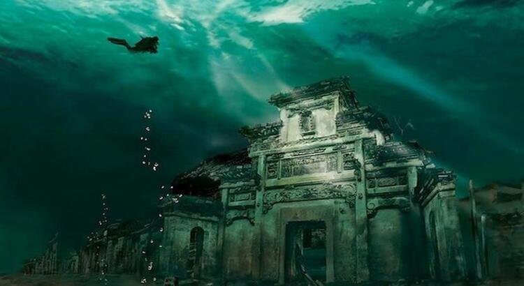
The Living Silence Beneath Waves
Beneath the surface of seas and oceans lie streets once walked by merchants, farmers, priests, sailors, and families. Their voices are gone, but their structures endure—quiet, submerged, and preserved in shifting light.
Marine archaeology continues to expand the map of drowned human history. Each discovery reminds us that civilization is not separate from nature but embedded within it, shaped by forces far older and more powerful than any city.
The real Atlantises are not myths of sudden divine destruction. They are scientifically documented records of environmental transformation, geological instability, and the profound interplay between humanity and the ocean.
And far below the moving surface of the sea, history waits—silent, intact, and patient—until curiosity descends to meet it.