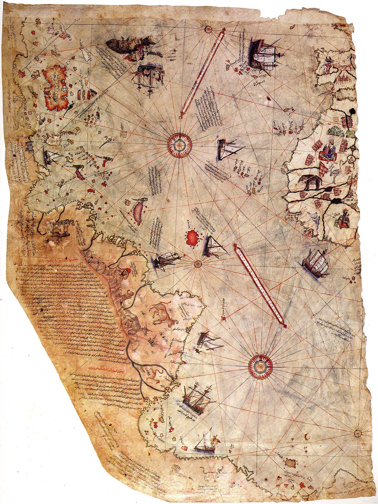
Imagine walking into an old library and unfolding a faded piece of gazelle skin that has survived for more than five centuries.
The ink has darkened with age, and parts of the map are missing forever. Along its edges, strange sea creatures swim across the oceans. Ships with billowing sails cross unknown waters. Elaborate compass roses point in every direction, while handwritten notes crowd the margins.
At first glance, it looks like many other Renaissance maps.
Then someone points toward the lower edge.
“There,” they say. “Some people believe that’s Antarctica.”
Immediately, the questions begin.
How could a map drawn in 1513 depict a continent that was not officially discovered by Europeans until more than 300 years later?
Even more astonishing, why do some claim it shows Antarctica without its massive ice sheets—revealing a coastline supposedly hidden beneath kilometers of ice?
It sounds like the beginning of a science-fiction novel.
For decades, the Piri Reis Map has inspired extraordinary theories. Some believe it is evidence of a forgotten advanced civilization. Others claim it proves ancient sailors mapped the entire world thousands of years ago. A few even argue it demonstrates contact with extraterrestrials.
These ideas have appeared in bestselling books, documentaries, television programs, and countless internet discussions.
But what does the evidence actually say?
The real story of the Piri Reis Map is every bit as fascinating as the myths surrounding it—not because it overturns history, but because it reveals how exploration, geography, and human imagination combined during one of the greatest ages of discovery.
The Discovery of a Forgotten Treasure
The map remained hidden for centuries.
In 1929, while scholars were cataloging manuscripts in Istanbul’s Topkapı Palace Museum, they made an extraordinary discovery.
Among forgotten documents lay part of a world map drawn on carefully prepared gazelle skin.
Although incomplete, the surviving fragment immediately attracted attention.
It displayed portions of Europe, Africa, and the newly explored Americas with surprising detail.
An inscription revealed its creator.
The map had been drawn in 1513 by Piri Reis, one of the Ottoman Empire’s most accomplished naval officers and cartographers.
Almost overnight, the forgotten manuscript became one of the world’s most famous historical maps.
Who Was Piri Reis?
Piri Reis was far more than a mapmaker.
Born around the late fifteenth century, he spent much of his life at sea.
He served as an admiral in the Ottoman navy, participated in numerous naval campaigns, and became widely respected for his knowledge of navigation and geography.
His experience extended across the Mediterranean, one of the busiest maritime regions in the world.
Sailors constantly exchanged information.
Ports served as centers of commerce where maps, charts, stories, and navigational techniques circulated among merchants and explorers.
Piri Reis understood that no single sailor could map the world alone.
Instead, he gathered knowledge from many sources.
His own writings explain exactly how he created his remarkable map.
A Map Built from Many Maps
One of the manuscript’s most important features is its explanatory notes.
Piri Reis openly stated that he compiled his map using numerous earlier charts.
According to his own account, he consulted approximately twenty different maps and nautical charts.
These included Portuguese maps of newly explored Atlantic coasts.
He also referred to Arabic maps, earlier Islamic geographical works, and charts attributed to Christopher Columbus, although no verified original Columbus world map survives today.
This admission is extremely important.
The Piri Reis Map was never intended to represent firsthand exploration of every coastline.
Instead, it was a synthesis—a carefully assembled compilation combining the best geographical knowledge available in the early sixteenth century.
In many ways, it resembles a modern atlas created from satellite images, survey data, and existing maps rather than one person’s direct observations.
The Age of Exploration
To understand the map, we must understand the world in which it was created.
The late fifteenth and early sixteenth centuries witnessed an explosion of geographical discovery.
European explorers sailed farther than ever before.
Portuguese navigators rounded Africa.
Spanish expeditions crossed the Atlantic.
New islands, coastlines, and trade routes appeared with astonishing speed.
Maps became incredibly valuable.
Governments guarded them as military secrets.
Accurate charts could determine whether ships reached profitable trade routes or vanished forever at sea.
Cartographers eagerly collected every fragment of new information.
The Piri Reis Map reflects this rapidly expanding geographical knowledge.
It captures a moment when the world’s picture was changing almost yearly.
What Does the Map Actually Show?
Only about one-third of the original world map survives today.
The missing portions probably included Europe, Asia, and much of the Indian Ocean.
The surviving fragment primarily depicts the Atlantic Ocean.
Western Europe appears on one side.
Northwestern Africa occupies another.
Across the ocean lie parts of South America and portions of the Caribbean.
Many coastlines are surprisingly recognizable.
The Iberian Peninsula appears clearly.
Western Africa is reasonably accurate.
The eastern coastline of South America resembles modern Brazil in several areas.
However, accuracy varies considerably.
Some islands are misplaced.
Distances are inconsistent.
Certain coastlines curve unnaturally.
These imperfections remind us that Renaissance cartography remained a developing science.
The Mystery Begins
The greatest controversy concerns the southernmost part of the surviving map.
A long landmass extends eastward beneath South America.
Some observers believe this represents Antarctica.
If true, the implications would be astonishing.
Antarctica was first sighted by confirmed European expeditions in 1820.
Its coastline remained poorly known for decades afterward.
Moreover, the continent is buried beneath an ice sheet averaging more than a kilometer thick.
How could anyone have mapped it in 1513?
The question fueled decades of speculation.
The Antarctica Claim
The most famous interpretation emerged during the twentieth century.
Some writers argued that the southern coastline shown on the map closely matched Queen Maud Land, a region of Antarctica.
Even more remarkably, they claimed it represented the coastline beneath the modern ice sheet rather than the visible ice-covered coast.
According to this idea, the original source maps must have been created thousands of years ago, before Antarctica became glaciated.
This extraordinary hypothesis implied the existence of an advanced prehistoric civilization possessing sophisticated geographical knowledge.
It was an exciting story.
It was also scientifically problematic.
Why the Antarctica Theory Became Popular
The Antarctica hypothesis spread because it appealed to something deeply human.
People love mysteries.
A map seemingly impossible for its time invites dramatic explanations.
Books proposed forgotten global civilizations.
Television documentaries suggested hidden histories.
Ancient astronauts entered the discussion.
Each new version became more sensational than the last.
Yet popularity is not evidence.
Science evaluates extraordinary claims by examining whether they match available data.
In the case of the Piri Reis Map, careful analysis has produced a very different picture.
What Professional Cartographers Found
Historians of cartography have studied the map in remarkable detail.
Rather than beginning with exciting conclusions, they carefully compared every coastline, inscription, and navigational feature.
Their findings challenge the Antarctica interpretation.
Most specialists conclude that the disputed southern landmass is better explained as a distorted continuation of South America’s eastern coastline.
Early explorers had not yet determined the continent’s true southern extent.
Many believed land continued much farther south than it actually does.
Combining information from multiple imperfect source maps could easily produce the exaggerated coastline seen on the Piri Reis Map.
Projection distortions further complicate comparisons.
When maps drawn using different methods are combined, coastlines may stretch, rotate, or curve unexpectedly.
These effects are common in historical cartography.
Antarctica Was Already Covered by Ice
Perhaps the strongest scientific argument against the Antarctica theory comes from geology.
Antarctica’s continental ice sheet did not appear recently.
Geological evidence shows that large-scale glaciation began tens of millions of years ago, during the Cenozoic Era.
The ice sheet has changed in thickness and extent through Earth’s climatic history, but there is no evidence that an ice-free Antarctic coastline existed within the timeframe of human civilization.
Modern radar can reveal rock hidden beneath the ice.
These subglacial landscapes differ substantially from the coastline suggested by supporters of the Piri Reis theory.
The geological evidence simply does not support the idea that ancient humans mapped an ice-free Antarctica.
The Challenge of Comparing Ancient Maps
One reason the controversy persists is that comparing historical maps with modern satellite images is surprisingly difficult.
Modern maps use carefully defined projections based on precise mathematical systems.
Sixteenth-century maps often combined information from many different sources.
Coastlines were sometimes rotated.
Distances could be compressed or stretched.
Unknown regions were occasionally filled using educated guesses.
If one selectively rotates, enlarges, or reshapes sections of an old map, surprising similarities can emerge almost anywhere.
This phenomenon is known as pattern matching.
Humans naturally recognize familiar shapes, even when similarities arise largely by chance.
Scientists therefore require much stronger evidence than visual resemblance alone.
The Remarkable Accuracy That Needs No Myth
Ironically, the Piri Reis Map is genuinely impressive without invoking Antarctica.
Its depiction of parts of the South American coastline reflects surprisingly current geographical knowledge for 1513.
This achievement demonstrates how rapidly information spread during the Age of Exploration.
Portuguese navigators had explored much of Brazil only years earlier.
Their charts circulated among maritime powers.
Piri Reis successfully incorporated this knowledge into his compilation.
That accomplishment alone represents a remarkable achievement in Renaissance cartography.
The Lost Sources
One fascinating aspect of the map is the documents upon which it was based.
Many of Piri Reis’s source maps have disappeared forever.
Some were likely Portuguese navigation charts.
Others may have originated in earlier Islamic geographical traditions.
Still others may have traced their ancestry through generations of copying.
Every lost map represents missing historical knowledge.
Although we cannot recover them directly, the Piri Reis Map preserves fragments of their information.
In this sense, it serves as a historical archive of even older cartographic traditions.
The Influence of Medieval Geography
The map also reflects medieval geographical thinking.
Cartographers often blended observation with inherited traditions.
Classical authorities such as Ptolemy influenced mapmaking for centuries.
Stories from sailors supplemented direct measurements.
Unknown regions sometimes contained speculative coastlines or islands.
Accuracy and imagination frequently coexisted on the same page.
Rather than viewing this as poor science, historians recognize it as an honest reflection of the available knowledge.
Cartographers worked with incomplete information and continually revised their understanding as new discoveries arrived.
Sea Monsters and Symbolism
Like many maps of its era, the Piri Reis Map includes artistic flourishes.
Sea creatures inhabit the oceans.
Ships sail across open waters.
Decorative elements fill otherwise empty spaces.
These illustrations remind us that Renaissance maps served multiple purposes.
They were scientific tools.
They were artistic creations.
They were political statements demonstrating geographical knowledge.
They were also objects of beauty.
Every detail reflected the worldview of their creators.
Modern Technology Studies an Ancient Map
Today’s researchers use advanced imaging techniques to study the manuscript.
High-resolution photography reveals faded details invisible to the naked eye.
Multispectral imaging can enhance damaged writing.
Digital analysis allows scholars worldwide to examine the map without physically handling the fragile parchment.
These technologies continue improving our understanding of how the manuscript was produced.
Yet they have uncovered no evidence supporting claims of prehistoric Antarctic mapping.
Instead, they reinforce the conclusion that the map belongs firmly within the cartographic traditions of the early sixteenth century.
Why Extraordinary Claims Require Extraordinary Evidence
The Antarctica debate illustrates an important principle of science.
An extraordinary claim demands exceptionally strong evidence.
Suggesting that humans mapped Antarctica before recorded history would require overwhelming archaeological, geological, historical, and cartographic support.
Such evidence has never been found.
Instead, multiple independent lines of research point toward a more ordinary—but still fascinating—explanation.
The map reflects the best geographical information available to an exceptionally skilled Ottoman cartographer who synthesized numerous earlier sources during one of history’s greatest periods of exploration.
That explanation fits both the manuscript itself and the broader historical record.
The Real Legacy of the Piri Reis Map
The enduring fascination of the Piri Reis Map does not come from proving impossible theories.
It comes from revealing how knowledge traveled across cultures.
An Ottoman admiral drew upon Portuguese discoveries, earlier Islamic scholarship, classical geographical traditions, and perhaps charts associated with Christopher Columbus.
The resulting map demonstrates that scientific knowledge has rarely belonged to a single civilization.
Instead, it grows through exchange.
Ideas cross oceans.
Maps pass from one navigator to another.
Observations accumulate across generations.
Each explorer builds upon those who came before.
The Piri Reis Map embodies this remarkable process.
Conclusion
The Piri Reis Map remains one of the world’s most captivating historical documents, but not because it rewrites the history of Antarctica.
Its true significance lies elsewhere.
It captures a remarkable moment when humanity’s picture of the world was expanding at breathtaking speed. Sailors ventured into unknown oceans. Empires competed for new trade routes. Cartographers struggled to combine fragments of knowledge into coherent representations of the Earth. Every new voyage altered the maps, and every map inspired further exploration.
The famous claim that the manuscript depicts an ice-free Antarctica has not withstood careful scientific examination. Modern geology shows that Antarctica’s ice sheet long predates human civilization, while historians of cartography find that the disputed southern coastline is more convincingly interpreted as a distorted extension of South America, shaped by the limitations of sixteenth-century mapping techniques and incomplete geographical knowledge.
Yet dismissing the Antarctica theory does not diminish the map’s wonder.
On the contrary, the genuine story is perhaps even more inspiring.
The Piri Reis Map reminds us that great achievements often arise not from impossible mysteries but from curiosity, collaboration, and the steady accumulation of knowledge. It stands as a testament to the skill of Renaissance navigators, the exchange of ideas across cultures, and the enduring human desire to understand the world beyond the horizon.
More than five hundred years after its creation, the map still invites us to ask questions.
Not because it contains evidence of a forgotten civilization, but because it preserves one of history’s greatest adventures—the moment when humanity was beginning to discover the true shape of its planet.