High on the windswept plains of western Bolivia lies one of the world’s greatest archaeological mysteries—a landscape so vast that it remained largely unnoticed for centuries. At first glance, the region appears to be an endless stretch of dry grasslands beneath the towering, snow-capped peak of Sajama Volcano. But from high above, an astonishing pattern emerges. Thousands upon thousands of perfectly straight lines crisscross the landscape, stretching across hills, valleys, rivers, and open plains with remarkable precision.
These are the Sajama Lines, an immense network of ancient pathways that covers an area larger than many countries. Unlike the famous Nazca Lines of Peru, which form giant animal and geometric figures visible from the air, the Sajama Lines create a gigantic web of straight routes extending across the Altiplano. Together they represent one of the largest and most extensive human-made landscapes ever discovered.
For archaeologists, geographers, and historians, the Sajama Lines are not merely lines scratched into the ground. They are evidence of centuries of human activity, engineering, belief, and movement across one of South America’s harshest environments. Even today, many questions remain about who built them, how they maintained such incredible accuracy, and what role they played in the lives of the ancient Andean peoples.
A Hidden Wonder of the Andes
The Sajama Lines are located in Bolivia’s Altiplano, a vast high-altitude plateau lying more than 3,700 meters (about 12,000 feet) above sea level. The network surrounds Sajama Volcano, the country’s highest mountain, whose snow-covered summit rises to over 6,500 meters (21,000 feet).
The region may seem empty today, but for thousands of years it has been home to Indigenous communities who adapted to the challenging environment. The landscape is dotted with small villages, grazing llamas and alpacas, ancient burial towers, ceremonial sites, and remnants of old settlements.
It is across this rugged plateau that the mysterious lines extend in every direction.
Unlike roads built by modern machinery, the Sajama Lines were created by simply removing the dark surface vegetation and stones, exposing the lighter soil beneath. This subtle alteration produced pale pathways that remain visible even after centuries of weathering.
Many of the lines are astonishingly straight. Some continue uninterrupted for several kilometers, crossing streams, uneven ground, and gentle slopes while maintaining their direction with remarkable consistency.
Discovery from the Sky
Although local people had always known about many of the pathways, the true scale of the Sajama Lines remained largely unrecognized until aerial photography and satellite imagery became available during the twentieth century.
Viewed from ground level, only short sections of the paths are visible. Standing among them, it is almost impossible to appreciate the enormous network surrounding you.
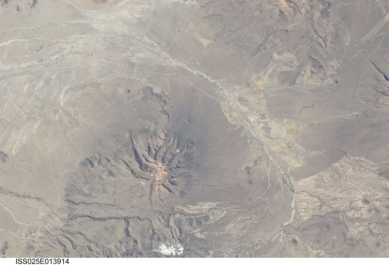
From the air, however, the landscape transforms into a vast geometric pattern.
Researchers realized that these were not isolated trails but an interconnected system stretching across thousands of square kilometers. The immense size of the network quickly attracted international attention because no comparable system of ancient pathways had ever been documented.
Satellite imagery has since revealed that the lines form one of the largest archaeological features on Earth.
The Largest Ancient Network of Lines
The Sajama Lines cover an extraordinary area estimated at more than 22,000 square kilometers (about 8,500 square miles). Within this enormous region are thousands of individual straight pathways.
If all of the lines were measured end to end, their combined length would total many thousands of kilometers.
This immense scale distinguishes the Sajama Lines from many other famous archaeological sites.
The Nazca Lines occupy a relatively limited desert plain in Peru.
The Sajama Lines, by contrast, spread across an entire landscape, linking distant places into an enormous interconnected network.
Rather than forming pictures visible from the sky, they resemble a giant web connecting communities, ceremonial locations, natural landmarks, and sacred mountains.
How Were the Lines Made?
One of the remarkable aspects of the Sajama Lines is the simplicity of their construction.
The builders did not excavate deep trenches or erect massive stone walls. Instead, they cleared away the dark vegetation, rocks, and surface material covering the ground.
This exposed the lighter-colored earth underneath.
Because the Altiplano has a dry climate with relatively little rainfall and slow vegetation growth, these cleared pathways remained visible for centuries.
Repeated walking likely helped maintain many of the routes over long periods.
Unlike modern roads designed for wheeled vehicles, these pathways were created for people and pack animals such as llamas.
Their construction required no advanced machinery, only careful planning, repeated labor, and generations of maintenance.
Remarkable Precision
Perhaps the greatest mystery of the Sajama Lines is their extraordinary straightness.
Some pathways continue over rolling terrain with minimal deviation.
They cross hills without curving around them.
They pass over streams.
They maintain their alignment despite changes in elevation.
Creating such straight routes without modern surveying instruments seems astonishing.
Ancient builders likely relied on simple but effective techniques involving distant landmarks, repeated observations, and careful alignment using the surrounding mountains.
The towering peaks of the Andes may have served as fixed reference points visible from great distances.
While researchers cannot reconstruct every surveying method used, the accuracy of the network demonstrates sophisticated knowledge of the landscape.
Who Built the Sajama Lines?
No single civilization can be credited with creating the entire network.
Instead, archaeologists believe the lines developed gradually over many centuries through the efforts of Indigenous communities living in the region.
The area has long been inhabited by Aymara-speaking peoples, whose ancestors occupied the Altiplano long before European arrival.
Evidence suggests that portions of the network may have originated before the rise of the Inca Empire and continued to be used during Inca times.
Rather than representing one massive construction project, the Sajama Lines likely evolved as communities expanded, interacted, traded, and performed ceremonial activities.
Generation after generation added new pathways while maintaining older ones.
The result was a living landscape shaped over centuries.
More Than Simple Roads
At first glance, the Sajama Lines may appear to be an ancient transportation system.
Indeed, they certainly allowed people to travel across the Altiplano.
However, archaeologists believe their purpose extended far beyond practical movement.
Many lines connect settlements, agricultural areas, burial sites, ceremonial platforms, springs, and sacred locations.
Some lead directly toward mountains that hold deep spiritual significance in Andean traditions.
Others intersect in ways suggesting organized patterns rather than random travel.
Because of these relationships, researchers increasingly interpret the network as both practical infrastructure and a ceremonial landscape.
Travel itself may have carried religious meaning.
Walking certain routes may have been an important part of rituals honoring ancestors, mountains, or spiritual beings.
Sacred Mountains in Andean Belief
To understand the Sajama Lines, it is essential to understand the importance of mountains in Andean cultures.
For many Indigenous peoples of the Andes, mountains are not simply geological features.
They are living spiritual beings.
Known in many traditions as sacred mountain spirits, they are believed to protect communities, provide water, influence weather, and watch over the land.
Sajama Volcano itself has long been regarded as an especially sacred peak.
Many pathways appear oriented toward prominent mountains, suggesting that journeys across the landscape may have been acts of devotion as well as transportation.
Walking the lines could have connected people not only with neighboring communities but also with the spiritual world.
Connections to Ancient Settlements
Archaeological surveys have shown that numerous Sajama Lines terminate at villages, burial towers known as chullpas, shrines, and ceremonial sites.
This pattern strengthens the interpretation that the network served social and religious purposes.
Rather than isolated roads leading nowhere, many routes connect meaningful destinations.
Communities likely used them for trade, communication, seasonal gatherings, pilgrimages, and cultural ceremonies.
Because many settlements changed over centuries, the network also evolved.
New paths were added while older ones continued to be respected.
The result resembles a living map recording generations of human activity.
Engineering Without Modern Technology
The Sajama Lines remind us that impressive engineering does not always require monumental stone buildings.
Instead, they demonstrate another kind of achievement: organizing human effort across a vast landscape.
Maintaining thousands of kilometers of pathways would have required cooperation among communities over many generations.
People needed shared knowledge about routes, destinations, maintenance, and cultural traditions.
The network therefore reflects social organization as much as physical construction.
Its survival speaks to the stability and continuity of Andean societies long before modern infrastructure existed.
Why Did the Lines Survive?
Many ancient structures disappear through erosion, farming, or urban development.
The Sajama Lines survived largely because of the environment.
The Altiplano’s cool, dry climate limits plant growth.
Relatively low rainfall reduces erosion.
Large portions of the region remain sparsely populated.
As a result, pathways cleared centuries ago remain surprisingly visible.
Nevertheless, the lines are not indestructible.
Modern roads, off-road vehicles, agriculture, mining, and construction can permanently damage sections of the ancient network.
Conservation efforts aim to protect this remarkable cultural landscape for future generations.
Comparing the Sajama Lines and the Nazca Lines
The Sajama Lines are often compared with Peru’s famous Nazca Lines because both involve ancient markings on the ground.
However, they are fundamentally different.
The Nazca Lines consist mainly of enormous drawings of animals, plants, geometric shapes, and straight lines etched into the desert surface.
Their exact purpose remains debated, though many researchers associate them with ceremonial practices and water-related beliefs.
The Sajama Lines, by contrast, are not giant pictures.
They form a transportation and ceremonial network connecting places across an immense region.
Rather than creating artwork visible from the sky, they organize movement through the landscape itself.
Both sites reveal extraordinary planning, but they represent different expressions of ancient Andean cultures.
Scientific Research Continues
Modern archaeologists use satellite imagery, aerial photography, geographic information systems (GIS), drone surveys, and field investigations to study the Sajama Lines.
These technologies allow researchers to map the network with remarkable precision.
By combining archaeological evidence with Indigenous history, environmental studies, and landscape analysis, scientists continue uncovering new insights into how the system developed.
Research suggests that the network cannot be understood by examining individual lines in isolation.
Instead, it must be viewed as an integrated cultural landscape in which travel, ceremony, settlement, and geography were deeply interconnected.
Each newly mapped pathway contributes another piece to this enormous historical puzzle.
Indigenous Knowledge and Living Heritage
Although archaeologists study the Sajama Lines as ancient monuments, the surrounding region remains home to Indigenous communities whose cultural traditions continue today.
Many aspects of Andean spiritual beliefs, respect for mountains, and traditional travel routes have survived despite centuries of change.
Collaborating with local communities provides valuable perspectives that archaeological evidence alone cannot offer.
Traditional knowledge helps researchers better understand how landscapes were experienced, remembered, and valued.
Rather than viewing the Sajama Lines as abandoned ruins, many scholars increasingly recognize them as part of a living cultural heritage.
Protecting an Extraordinary Landscape
Preserving the Sajama Lines presents unique challenges.
Because the network extends across such a vast area, protecting every pathway is difficult.
Unlike monumental temples enclosed within archaeological parks, the Sajama Lines spread across open land still used for grazing and local livelihoods.
Conservation therefore requires balancing cultural preservation with the needs of local communities.
Education, responsible tourism, archaeological documentation, and careful land management all play important roles in safeguarding this remarkable landscape.
The more scientists learn about the lines, the more valuable they become as part of humanity’s shared cultural heritage.
A Mystery That Continues to Inspire
Even after decades of research, many questions remain unanswered.
Exactly when were the earliest lines created?
How were surveying techniques developed?
Did different communities build different sections?
Which routes served practical travel, and which held primarily ceremonial meaning?
How did the network change over hundreds of years?
Each new archaeological investigation provides additional clues, but the complete story has yet to emerge.
That continuing mystery is part of what makes the Sajama Lines so captivating.
Seeing the Landscape Differently
Modern travelers often think of roads as simple routes from one place to another.
The Sajama Lines invite us to see movement differently.
For the ancient peoples of the Altiplano, walking across the landscape may have connected communities, ancestors, sacred mountains, trade partners, and spiritual beliefs all at once.
The journey itself carried meaning.
Every carefully maintained path represented countless footsteps taken over generations.
Together those footsteps created one of the largest human-made landscapes on Earth.
The Legacy of the Sajama Lines
The Sajama Lines stand as a remarkable reminder that great civilizations do not always leave behind towering pyramids or colossal temples. Sometimes their greatest achievement is written directly onto the land itself.
Stretching across the high plains beneath Bolivia’s tallest mountain, this immense network reflects centuries of cooperation, cultural tradition, engineering skill, and spiritual belief. Built with little more than human determination and intimate knowledge of the landscape, the lines continue to challenge archaeologists while inspiring admiration for the people who created them.
Although many mysteries remain, one fact is clear. The Sajama Lines are not random marks upon the earth. They are the enduring traces of generations who transformed an immense Andean landscape into a living network of connection, memory, and meaning—a masterpiece visible only when we step back far enough to see the extraordinary vision woven across the plains of Bolivia.